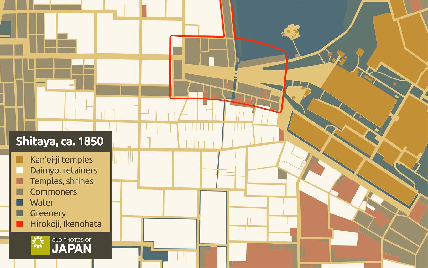
Shitaya (present-day Ueno in Tokyo), based on a 1850 woodblock print map. The top right shows part of Shinobazu Pond. This article looks at how I create original maps for Old Photos of Japan.
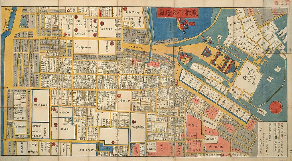
Here is the original map on which the above map is based.
The other day, a subscriber to Old Photos of Japan called one of my maps of Japan “very clean.” He asked what I use to create my maps:
What do you use to make your maps of Japan? You include different ones in the blog posts, but it looks like you regularly use a simple map, adding markings and text as needed to give readers a sense of where things are happening.
I don’t use any map-making apps, nor AI. I either use original vintage maps from my own collection or create maps by hand. In these maps, I deliberately hand-draw most lines. When you look carefully, you will often notice crooked ones.
I fix obvious errors, but I prefer messy lines when they don’t interfere with understanding. I believe this adds character and a feeling of warmth and intimacy. It makes the map a bit more personal. Perhaps even quirky.
I hope these maps convey that my articles are crafted with love, respect, and personal attention to detail and integrity.
Patiently tracing an existing map instead of using map-making apps or AI allows me to make more nuanced decisions about what to include and leave out without losing fidelity. It forces me to think more deeply about what message the map is intended to convey.
The drawback is perhaps that it is labor-intensive. Some maps have taken many days to create, more time than many authors spend writing an entire article.
To me, this is not necessarily a drawback, though. I enjoy focusing on the same thing for a long time. It is a bit like meditation. Time warps and the whole world around me vanishes. Only the thing in front of my eyes and my concentration remain. I also love the feeling of satisfaction when I look at a completed map that is almost exactly as I envisioned it in my mind’s eye.
Many maps on Old Photos of Japan are vintage maps with numbered arrows to locate places introduced in the article. For example, this 1903 (Meiji 36) Map of Kyushu, used in Human Conveyor Belt (2) and Human Conveyor Belt (3).

But today, I would like to focus on custom-made maps:
Map of Japan
The custom-made map you most often encounter in Old Photos of Japan articles is a very basic map of Japan, without the southwestern islands.
In Birth of a Nation, this map was used to show the major transport connections in Edo and early Meiji-period Japan. At a single glance, you can see how surprisingly well-connected Japan was during the Edo Period (1603–1868).

| Color | Road | Destination | Stations * |
|---|---|---|---|
| Tōkaidō | Kyoto and Osaka | 57 | |
| Nakasendō | Kyoto | 69 | |
| Kōshū Kaidō | Suwa, Nagano | 44 | |
| Nikko Kaidō | Nikko, Tochigi | 21 | |
| Ōshū Kaidō | Shirakawa, Fukushima | 27 | |
| Major Subroutes | - | - | |
| Major Sea Routes | - | - |
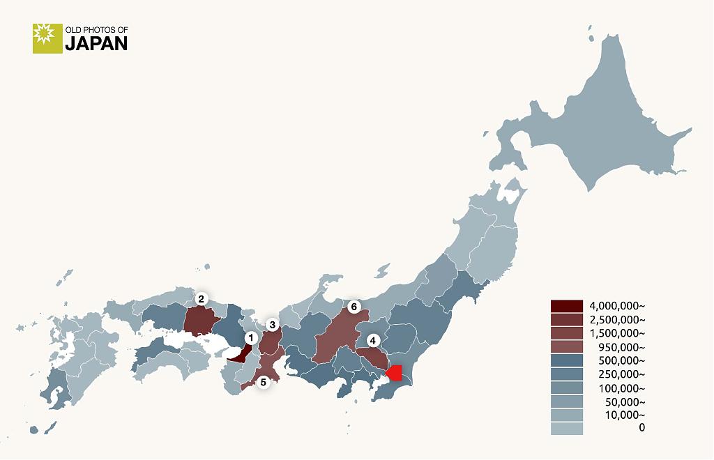
Occasionally, I extract data from vintage sources and add that to the map, as I did in this map of fertilizer volume shipped by prefecture in 1887 (Meiji 20). It was used in Japan’s Green Revolution (1).
The map visualized how almost 68% of fertilizer sales were concentrated in just six of the 29 prefectures covered by the survey: Osaka, Okayama, Shiga, Saitama, Mie, and Nagano. Due to a lack of modern transportation facilities, sales were almost nonexistent in isolated areas. It shows how Meiji Japan’s industrialization and modernization were limited to a relatively small area of the country.
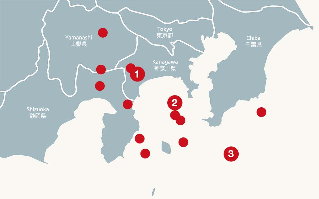
Sometimes I use only a small section of the Japan map, as seen in this map of the seismic activity of the Great Kantō Earthquake in 1923 (Taishō 12). This map was used in Drowning in a Sea of Fire. The same article also features two vintage maps that show how some 134 fires spread after the earthquake.
Adding Data to a Vintage Map
Occasionally, I add information to an original vintage map. In this 1894 (Meiji 27) map of Shinjuku, I added color to better distinguish buildings, tea plantations, groves, and so on. Today, Shinjuku is a concrete jungle with the world’s busiest train station. The main aim of this map was to show how rural it used to be. Just look at all those large tea plantations!
I wanted to help readers more easily locate this area in modern Shinjuku and visualize the massive size of the tea plantations. So, I added translucent white overlays of the Hilton Hotel, the Tokyo Metropolitan Government Buildings, and the Keio Plaza Hotel (letters A, B, and C in black circles).
The map was used in Shinjuku’s Lost Paradise (1).

⬤ Buildings
⬤ Tea plantations
⬤ Groves (including bamboo)
⬤ Water
⬤ Railway
Original Maps
I also create completely original maps with data sourced from a variety of primary sources. The map below shows a forgotten pond in Shinjuku as it looked during the 1800s. The information was gleaned from maps and books, but mostly from carefully studying photographs, drawings, and woodblock prints. It may contain minor errors, but it is a map that did not previously exist.
The map was used in Jūnisō Pond Chronology. One of the other maps in this article was based on a 1938 (Showa 13) map made by a fire insurance company.

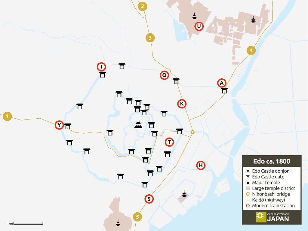
The next map shows Edo (present-day Tokyo), ca. 1800. It features Edo Castle, 27 of the 36 castle gates, major temples, and the intricate canal system that the Tokugawa Shogunate dug. For easier orientation, modern stations have been added. It was used in A Castle in a Marsh.
The map shows the immense size of Edo Castle and how large temple complexes protected it to the north and south. The map also shows the highways (kaidō). When one reads historical accounts of Japan, their names appear regularly. Yet their routes through present-day Tokyo can be surprisingly difficult to retrace. This map clearly shows how they dissected the city and met at Nihonbashi Bridge.
Upcoming Maps
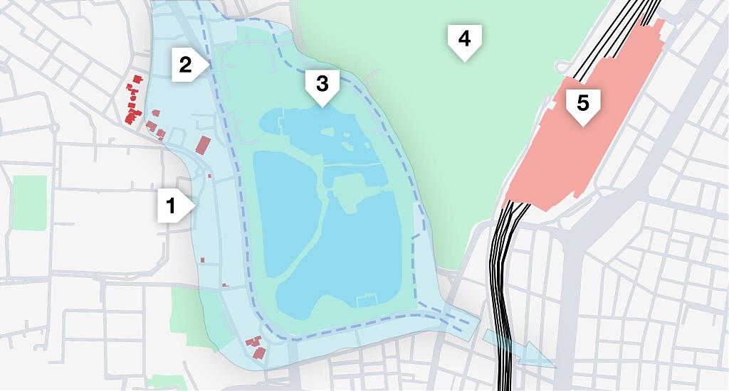
The map below is planned for my next article. It shows how Ueno’s Shinobazu Pond changed over the centuries. It used to be three times as large as it is today and reached from Ueno Hill (on the right) to Hongū Hill (on the left). Today, one can walk around the pond, but when Tokugawa Ieyasu arrived in 1590, this was impossible. There were roads on the hills, but not in the valley. It was all water.
This map combines information from a map in a 1932 (Showa 7) history book with a modern map of Shinobazu. Each line has been drawn by hand.
I am currently also working on an interactive map of Ueno in the early 1920s. It is based on data extracted from old phonebooks, directories, court reports, cadastral surveys, and other sources. It is an extremely detailed map featuring information that I have not been able to find anywhere else.
Next time you see a custom map in one of my articles, have a good look and feel free to ask me any questions that pop up! I’ll be happy to answer them.
Incidentally, I have hundreds of original vintage maps in my collection. If you ever need an old map for a project, let me know. I may have what you need. A tiny selection of maps can be found in my online archive, MeijiShowa.
This rescue project is funded by readers like you
Old Photos of Japan provides thoroughly researched essays and rare images of daily life in old Japan free of charge and advertising. Most images have been acquired, scanned, and conserved to protect them for future generations.
I rely on readers like you to keep this online museum going.
Sources for Map of Jūnisō in the 1800s
1 角筈村熊野神社絵図面, early Meiji Period, 819-1-175, National Diet Library.
2 淀橋浄水工場平面圖, 東京市水道要覧, 東京市水道改良事務所, 明治26年10月, 5001141601, 東京都立図書館デジタルアーカイブ.
3 野崎正興; 中垣創三 (2018). 『角筈十二社の大瀧に関する一考察(神田川助水堀内の大瀧)』新宿つつじの会.
4 Original research.
There are currently no comments on this article.