
On this aerial photo of Tokyo Station you can see a waterway above the station. There is no waterway there today. What is this and what happened?
This waterway is the outer moat (外濠, sotobori) of the former Edo Castle—the residence of the shōgun during the Edo period (1603–1868)—which became the Imperial Palace in 1868 (Meiji 1). The castle covered a much larger area than the current palace, with Tokyo Station and Marunouchi located in the area that used to be within the outermost moat.
On the following map from 1879 (Meiji 12) the layout of the Edo period still pretty much remains. Number 3 marks the Sotobori outer moat and number 5 the future location of Tokyo Station.
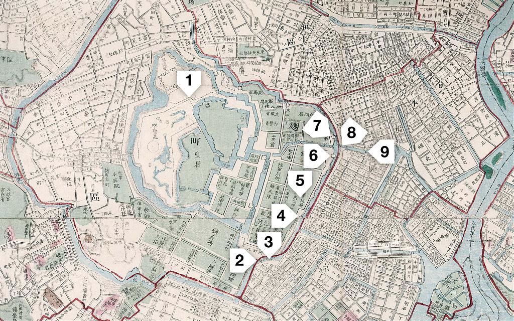
Notice all the bridges in the area. The Tokiwabashi (7), Ikkokubashi (8), and Nihonbashi (9) bridges still exist, albeit not in their original form. Sukiyabashi (2), Kajibashi (4), and Gofukubashi (6) only live on in name.
You may have heard one of these three names. Sukiyabashi Jiro became world famous in 2009 when it became the first sushi restaurant in the world to receive three stars from the Michelin Guide. A fascinating documentary about the restaurant, Jiro Dreams of Sushi, came out in 2011. And in 2014, U.S. President Barack Obama dined here with Japanese Prime Minister Shinzō Abe.
The restaurant’s name was derived from the bridge and it is located close to where the bridge used to stand. There also is a Sukiyabashi Park.
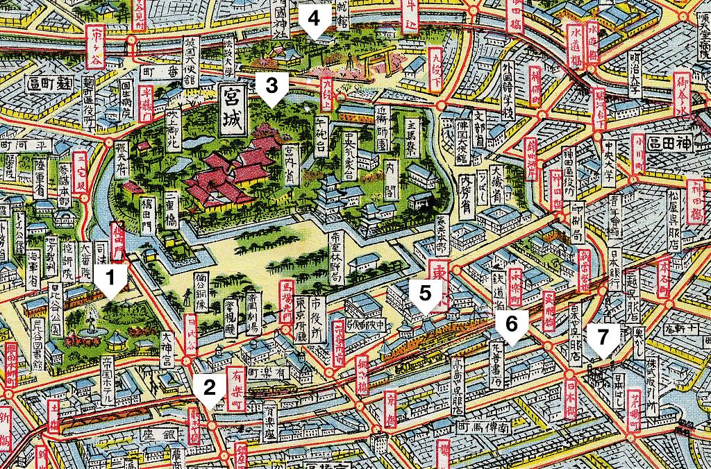
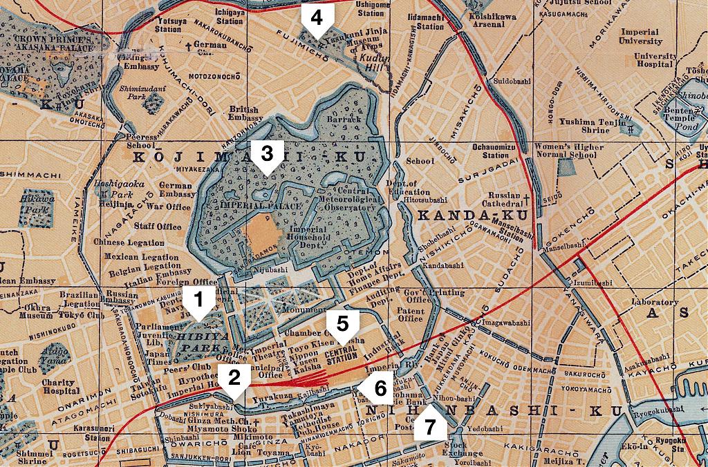
You may remember the following two maps from the article about Tokyo Station. They show the area as it looked when the top photograph was taken.
Views
So, what did the moat look like? As everything in Tokyo, it changed dramatically over the years. Let’s first look at a view of the Sotobori from what is now Yaesu looking towards Nihonbashi as it was in the 1870s.
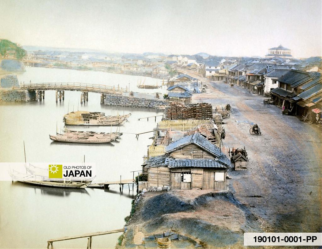
The bridge in front is the Gofukubashi Bridge (呉服橋), number 6 on the top map. The bridge slightly to the right in the background is the Ikkokubashi Bridge (一石橋). The bridge on the far left is the Tokiwabashi Bridge (常盤橋).
The large Western building on the far right is Mitsui Youkan (駿河町三井洋館) in Nihonbashi’s Suruga-cho (駿河町). The Mitsui Youkan was completed in 1874 (Meiji 7), so this photo dates from after that date.
Let’s have a closer look at the Tokiwabashi, the bridge in the left background of the above photo.
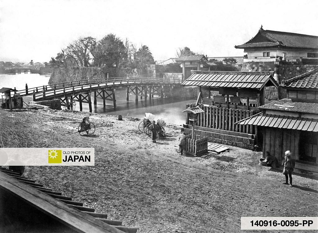
In the center background is the Tokiwabashimon Gate (常磐橋門). On the far left the Gofukubashi is visible. Notice the tower behind the bridge. This was almost certainly the location from which the previous photo was shot. On the right is an official bulletin board (高札場, kosatsujo).
The Tokiwabashimon was Edo Castle’s entryway to the Ōshu Kaidō (奥州街道), a major highway connecting Edo (pre-1868 Tokyo) with Mutsu Province (陸奥国, the area around Fukushima, Miyagi, Iwate and Aomori Prefectures). It was one of the “five entrances to Edo” (江戸五口, Edo Itsu Kuchi) which connected Edo Castle with the five major highways.
The merchant quarters of Nihonbashi, which became the heart of Edo, grew up and prospered outside this gate.
From 1873 (Meiji 6), the stone walls of the gate were partly demolished. The remains were designated a Historic Site in 1928 (Showa 3). The wooden bridge was replaced by a western-style stone structure in 1877 (Meiji 10), which still stands today.
This rescue project is funded by readers like you
Old Photos of Japan provides thoroughly researched essays and rare images of daily life in old Japan free of charge and advertising. Most images have been acquired, scanned, and conserved to protect them for future generations.
I rely on readers like you to keep this project going.
Let’s next go to the other side of Tokyo Station, to the Sukiyabashi Bridge (数寄屋橋), number 2 on the top map.
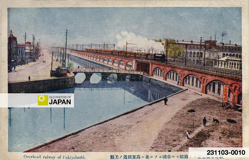
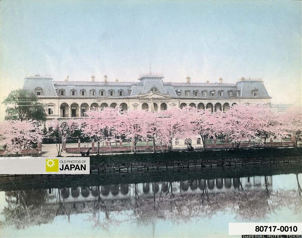
This postcard shows the Sotobori and Sukiyabashi as it looked around 1920. The large building behind the train is the first Imperial Hotel. It opened on November 20, 1890 (Meiji 23) and was destroyed by fire on April 16, 1922 (Taisho 11), conveniently dating this postcard to before that date.
The following photo shows what the Imperial Hotel and the Sotobori looked like in the 1890s, before the elevated railway was built.
The next image is a view of the Sukiyabashi as it looked around 1930 (Showa 5). This time we are looking in the direction of Tokyo Station.
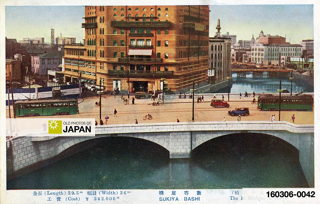
The first Sukiyabashi was built in 1629 (Kan’ei 6). Sukiya means tea ceremony room. At the time that the bridge was built, many retainers lived in this area whose duty it was to perform the tea ceremony for the Shogun. The bridge was dismantled in 1929 (showa 4) and the new bridge in this postcard was built several hundred meters away.
This postcard is from the postcard series The 16 Bridges of Tokyo (東京大十六橋, Tōkyō Dai Jūrokubashi). Following the Great Kantō Earthquake of September 1, 1923 (Taisho 12), Tokyo celebrated the official completion of its earthquake reconstruction in March 1930. As part of the project, hundreds of bridges were built or reconstructed. This series appears to have been published to coincide with the celebration.
Sayonara Sotobori
The moat and the bridges survived WWII, but the Sotobori between the Gofukubashi and Kajibashi bridges (numbers 4 and 6 on the top map), basically today’s Yaesu area, was filled in with WWII rubble by 1949 (Showa 24). The rest of the moat in this area was filled in between 1954 (Showa 29) and 1959 (Showa 34).
Where once water flowed there now is a very busy road. Next time when you enter or exit Tokyo Station from the Yaesu side spend a few thoughts on the important waterway that used to be there.
Let’s end on a positive note. Thankfully, part of the outer moat has survived on the other side of the Imperial Palace. In 2016, a coalition of companies with headquarters along the Sotobori established the “Outer Moat Waterfront Restoration Council” (外濠水辺再生協議会, Sotobori Mizube Saisei Kyōgikai) to improve the landscape and conserve historical sites along the remains of the moat, and to purify its water.1
There is hope.
Notes
1 「みんなの外濠!」 Retrieved on 2023-10-02.
Published
Updated
Reader Supported
Old Photos of Japan aims to be your personal museum for Japan's visual heritage and to bring the experiences of everyday life in old Japan to you.
To enhance our understanding of Japanese culture and society I track down, acquire, archive, and research images of everyday life, and give them context.
I share what I have found for free on this site, without ads or selling your data.
Your support helps me to continue doing so, and ensures that this exceptional visual heritage will not be lost and forgotten.
Thank you,
Kjeld Duits
Reference for Citations
Duits, Kjeld (). Tokyo 1920s: Sotobori at Tokyo Station, OLD PHOTOS of JAPAN. Retrieved on July 21, 2026 (GMT) from https://www.oldphotosjapan.com/photos/923/history-sotobori-outer-moat-tokyo-station-vintage-postcard-1920s


Matthew Hall
Thank you for this and the other Tokyo Station-related entries as I just love the brick station building, hotel, the surroundings and the history that wraps it all together!
#000787 ·
Kjeld (Author)
@Matthew: Thank you for your kind words! The exterior of Tokyo Station always makes me happy. It exudes so much character.
#000788 ·