
A spectacular view on the city of Tokyo from Atago-yama, a hill some 26 meters above sea-level.
Shops and dwellings have taken the place of the great residences of the daimyo. In the far background, the roof of Tsukiji Honganji Temple can be seen. Beyond that is Tokyo Bay.
During the Edo Period, Atago-yama was a popular place for people to enjoy watching the moon. It was also a great place to photograph panoramic views of the city. The earliest surviving panoramic view shot from here was taken by Felice Beato around 1865 (Genji 2).
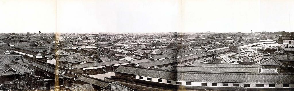
By the time Nobukuni Enami photographed this area, the residences of the daimyo, still visible on Beato’s image, had long since been torn down or used for other purposes. But the basic lay-out was the same. Something that cannot be said anymore today.
When Edo was built, careful consideration had been made to conserve the views from the city. The direction of Edo’s main streets offered impressive views of all of the city’s scenic spots, including Atago-yama. Some other places that were clearly visible from the city were Mt. Fuji, the Musashino Plain, the Sumida River, Mt. Tsukuba, Mt. Kanda, the Yushima and Hongo Plateaus, Shinobugaoka (Ueno), the Main Enclosure and Nagatacho Plateaus, Shiba-Zojoji Urayama and Shiba Maruyama.
These days, developers have lost the wisdom of the planners of the Edo Period. Almost all the beautiful views are now obscured by high-rises.
Published
Updated
Reader Supported
Old Photos of Japan aims to be your personal museum for Japan's visual heritage and to bring the experiences of everyday life in old Japan to you.
To enhance our understanding of Japanese culture and society I track down, acquire, archive, and research images of everyday life, and give them context.
I share what I have found for free on this site, without ads or selling your data.
Your support helps me to continue doing so, and ensures that this exceptional visual heritage will not be lost and forgotten.
Thank you,
Kjeld Duits
Reference for Citations
Duits, Kjeld (). Tokyo 1890s: View from Atago-yama, OLD PHOTOS of JAPAN. Retrieved on August 3, 2026 (GMT) from https://www.oldphotosjapan.com/photos/132/view-on-tokyo


There are currently no comments on this article.